
In January this year, I posted an early-season review of the start of the 2019/2020 snow season here in Hokkaido. The main takeaway from that post was that while the start to the 2019/2020 season wasn’t the slowest on record, it was definitely a slow start. Things generally picked up after that though, and we ended up having one of the most well-rounded seasons many of us could remember – good snow and more blue-sky touring days than we could remember.
METHOD
Using the Japan Meteorological Agency’s data download service, I’ve downloaded all of the available daily snowfall and snowpack depth data for four low-lying locations and four higher-up locations in Hokkaido.
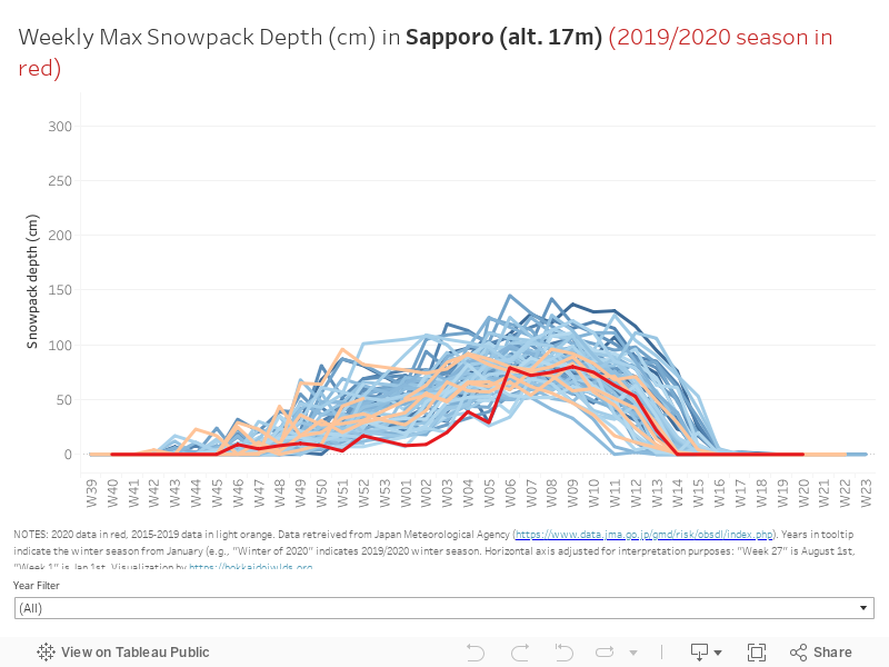
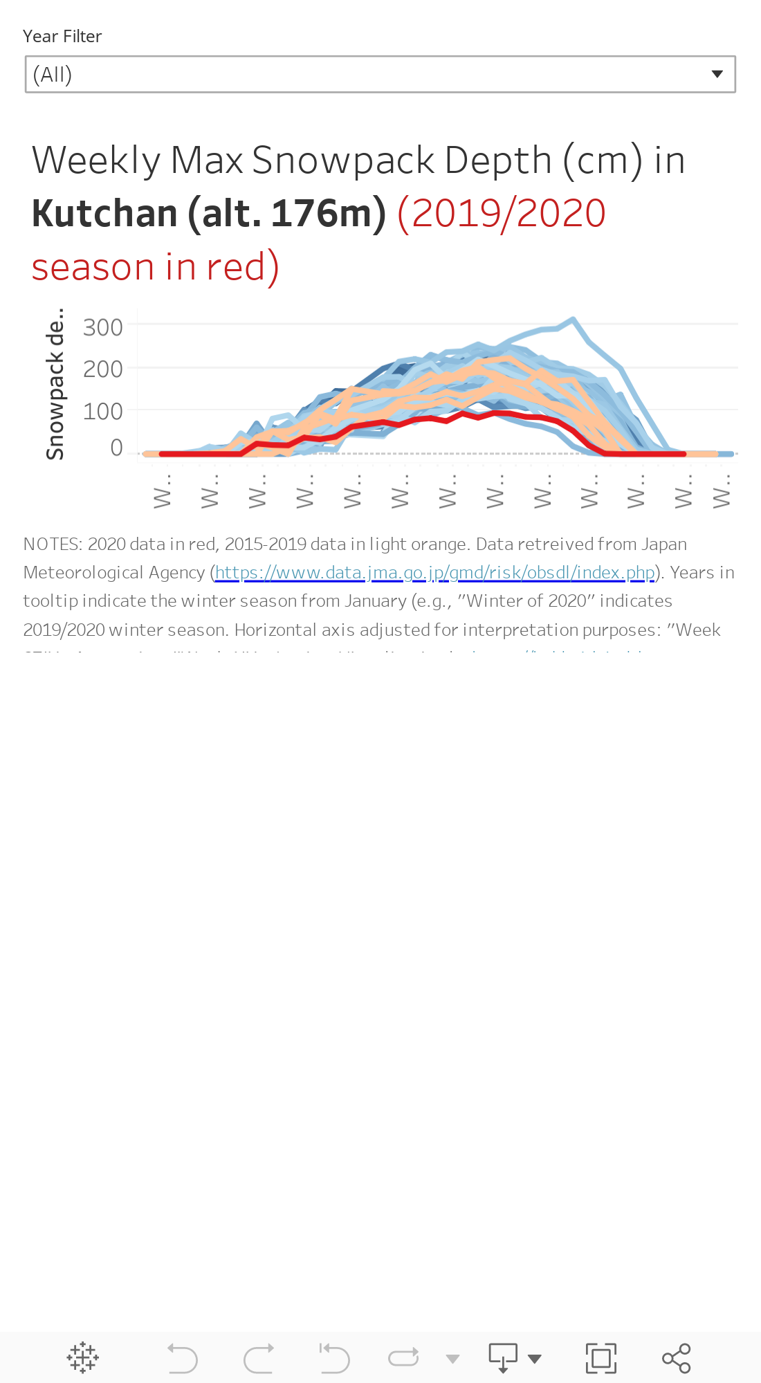
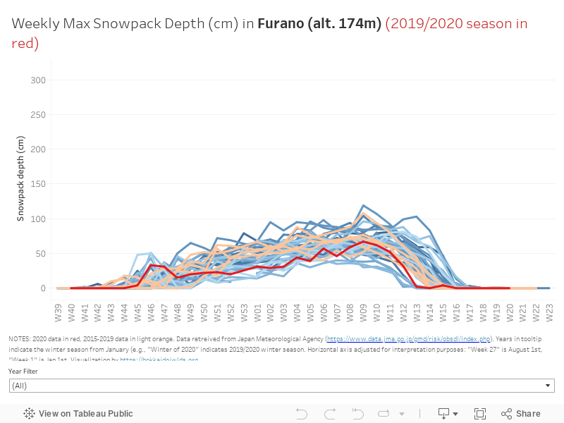
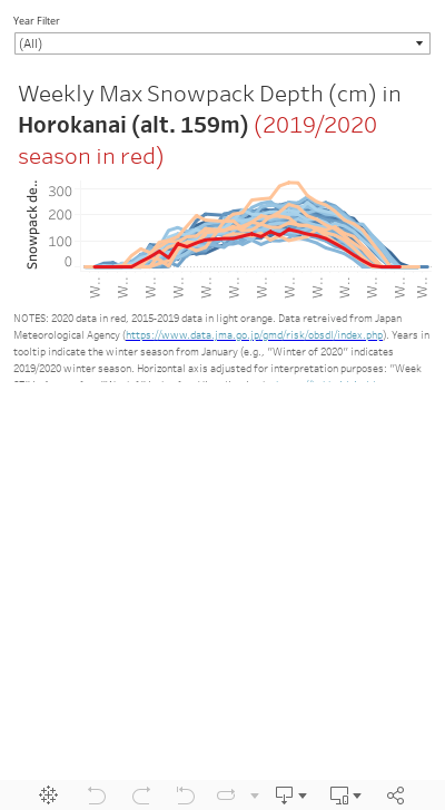
The low-lying locations – chosen for their proximity to well-known good backcountry skiing – are Sapporo City (altitude 17m), Kutchan (176m) near the well-known Niseko ski resort area, Furano City (174m) and one of our favourite ski touring locales of all time, Horokanai (159m).
I’ve also chosen the four highest-altitude weather stations the meteorological agency publishes data for in Hokkaido. I included these to get a feel for how higher altitude locations might have fared in this low-tide 2019/2020 Hokkaido snow season. According to the Japan Meteorological Agency’s 80-year predictions, compared with now, higher altitude areas in Hokkaido – particularly in central Hokkaido – will see increases in snow volume by the turn of the century. Those higher-altitude weather stations are Nukabira Onsen ( altitude 540m), Sounkyo (540m), Shirataki (475m), and Akanko Onsen (450m). The first three are in central Hokkaido.
- Download all data used in this post: MASTER-snow-high-low.csv
KEY POINTS
Despite comparatively low snow levels this year, the 2019/2020 winter season in Hokkaido was one of the best we’ve had – plenty of snow, and unusually stable, clear weather. Great for long ski touring days.
I’ve pulled 40-60 years of daily data about snowpack and snowfall from eight weather stations around Hokkaido. The 2019/2020 winter in Hokkaido had some of the lowest snowfall and snowpack in recorded history. While some areas suggest no historical downward trend in snowfall and/or snowpack depth, some do.
This echoes the Japan Meteorological Agency’s (JMA) 80-year climate predictions: given current trends, many areas in Hokkaido will see reductions in snow by the turn of the century, but some will see increases.
Weather Station Data Used
Low-lying locales in red, higher-up locales in blue.
1. LOW-LYING LOCALES
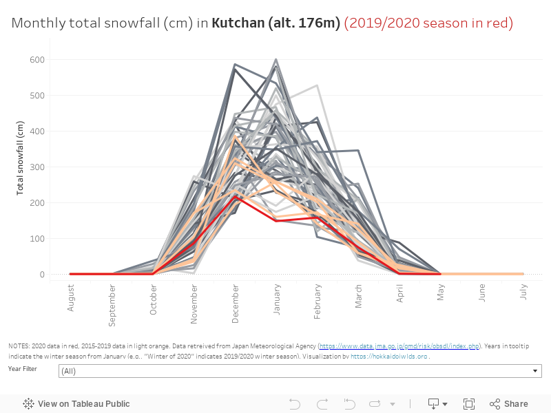
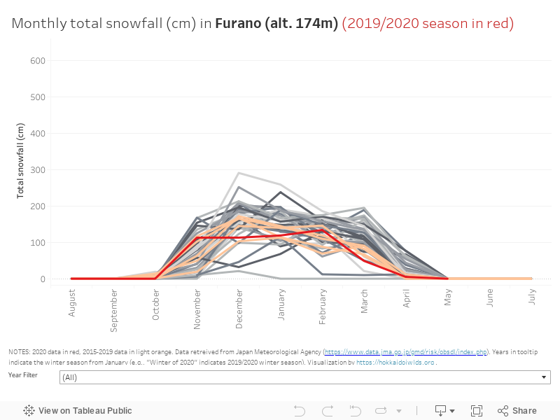
I’ll start with the more weather station data from the more well-known areas – all of which are quite low altitude. Therefore, at best this data should be considered as only marginally representative of the snowfall surrounding mountain areas may have received. The data should, however, give some feel for how the 2019/2020 season (the red line in the figures below) stacks up against years gone past. Overall, I think the data shows well that the 2019/2020 winter season was certainly a low year. The data suggests that in particular Kutchan – near Niseko – had a record-setting abysmal year for snowpack and snowfall by historical standards.
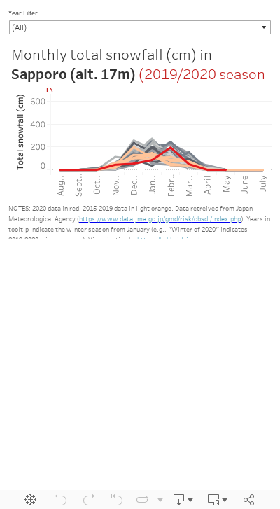
- How to read the figures: The horizontal axis on the line-plots below shows the week numbers for each winter season. For example, for the 2019/2020 season, W40 is week number 40 in 2019 (Sept 30th 2019), W01 is Jan 1st 2020. The red line is the 2019/2020 season. The pale orange lines are the five seasons prior to 2019/2020. Blue/black lines are all other available historical data (1961~ for Sapporo and Kutchan, 1980~ for the rest).
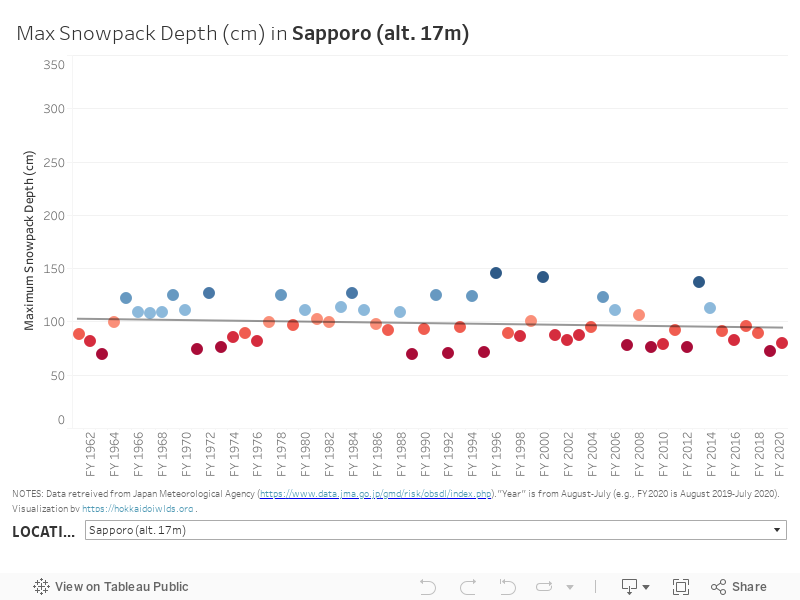
1.1a SNOWPACK | Weekly Maximum Depth – 2020 Compared
Here’s snowpack depth data for the four low-lying areas. Each day, the depth of the snowpack is measured in an undisturbed location at weather stations. Here, I’ve visualized the maximum snowpack depth recorded during any given week (the base data is daily). This measure will always be lower than the total snowfall, because it doesn’t take much for new snowfall to compress older snowfall. Snowpack can also decrease from week to week, if there’s no new snow, due to compression and melting. Overall, the snowpack was among some of the lowest on record – but not the lowest ever.
Note: 2019/2020 season is shown in dark red, 2015-2019 seasons in light orange, pre-2015 in shades of blue.
1.1b SNOWPACK | Weekly Maximum Depth – Historical Trends
The above figures give a visual taste for how 2020 compares with other years. However, they don’t give insight into trends. Are we seeing shallower snowpack? At the bottom of the figure below, you can choose from the four low-lying locations to get a feel of historical trends in snowpack depth. I’ve overlaid trend lines, however none of them are statistically significant. This means that this data doesn’t indicate any general downwards trend in maximum snowpack depth at this point.
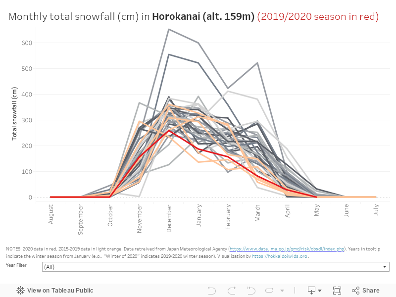
1.2a SNOWFALL | Monthly cumulative totals compared
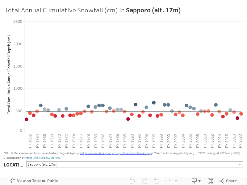
Now let’s move on to snowfall. Below, the figures show the cumulative total snowfall each month of each year there’s data for. The underlying data is daily, so each day’s snowfall is added up to get the sum total monthly snowfall. This data mirrors the snowpack data in the sense that the 2019/2020 season saw some of the lowest snowfall since records began in many of the locations below.
1.2b SNOWFALL | Monthly total snowfall – Historical Trends
OK, so the 2019/2020 season snowfall was quite low. But is there any trend regarding snowfall volume? Is there less snow falling from the sky over the years? Using the ‘Location’ filter on the figure below, we can see that for Sapporo and Furano, the answer seems to be no. For Kutchan and Horokanai, however – two of Hokkaido’s deepest and coldest areas – the answer is yes. There is a statistically significant downward trend in snowfall volume.
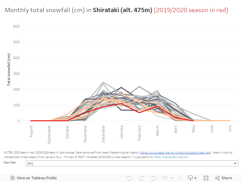
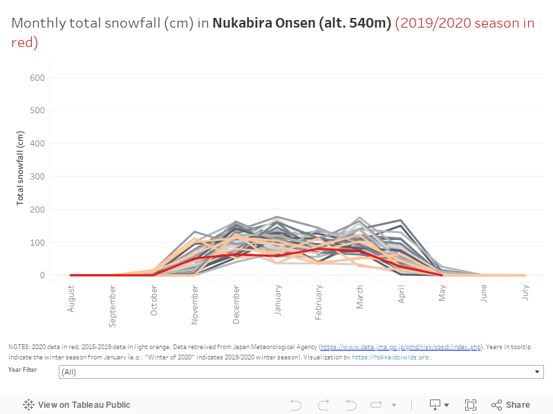
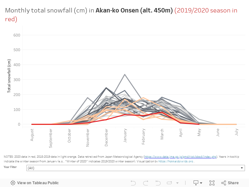
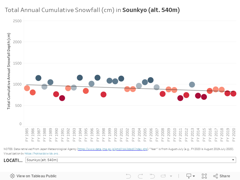
2. HIGHER-UP LOCALES
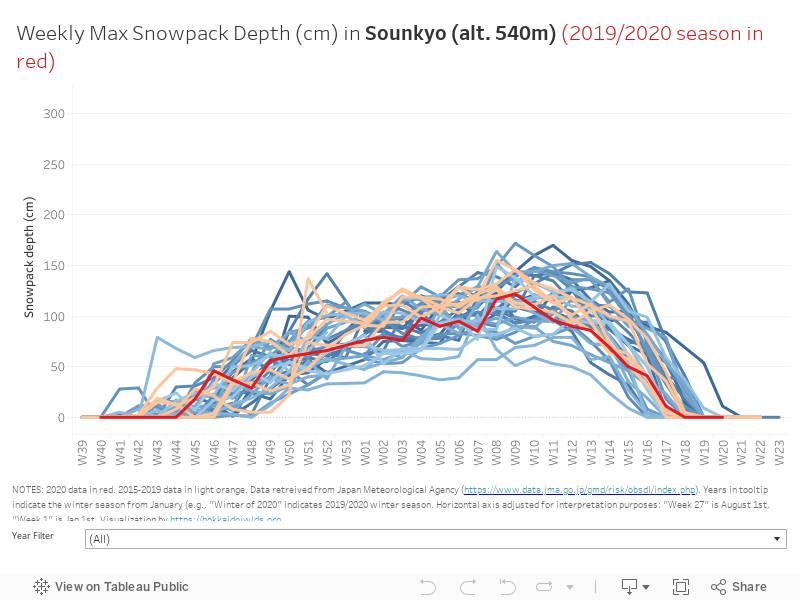
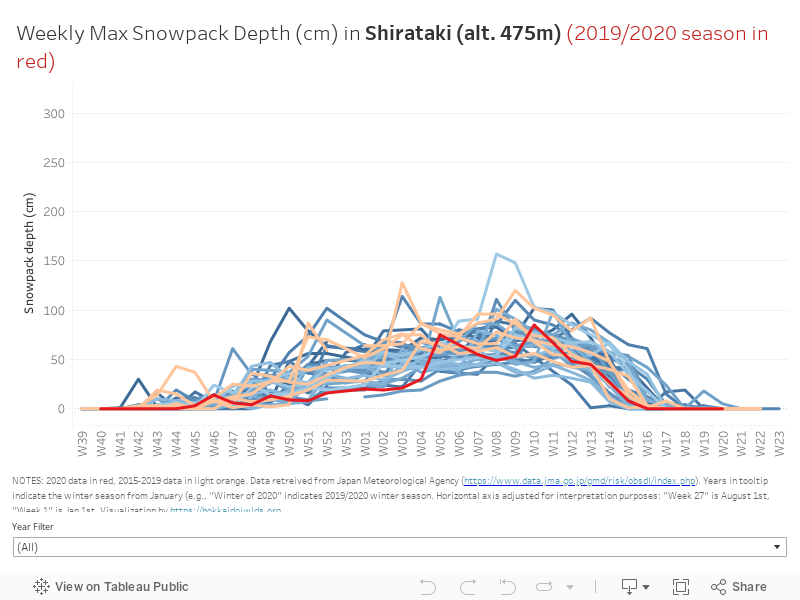
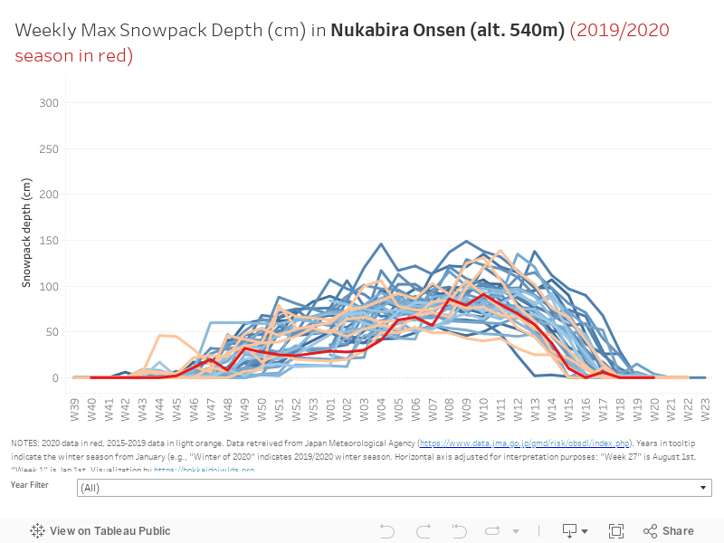
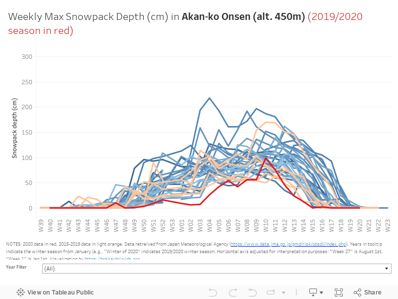
2.1a SNOWPACK | Weekly Maximum Depth – 2020 Compared
Once again, I start with the weekly maximum recorded snowpack depth. Sounkyo looks like a fairly average sort of a year. The other locations definitely got off to a late start.
Note: 2019/2020 season is shown in dark red, 2015-2019 seasons in light orange, pre-2015 in shades of blue.
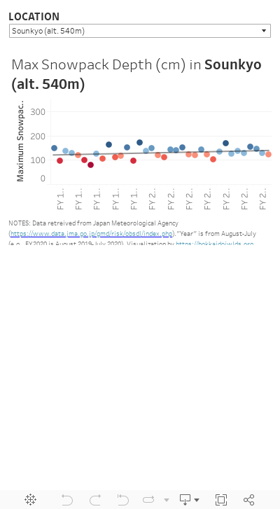
2.1b SNOWPACK | Weekly Maximum Depth – Historical Trends
Again, the above figures give a visual taste for how 2020 compares with other years. However, they don’t give insight into trends. Using the LOCATION filter on the figure below, we can see that in these higher altitude locations, there’s no statistically significant change in snowpack depth over the last 30 years or so. This is in stark contrast to places like Kutchan and Horokanai, in the ‘low-lying locales’ outlined in the section above.
2.2a SNOWFALL | Monthly cumulative totals compared
Monthly total snowfall for the four higher-altitude locations are certainly at the lower end of historical records.
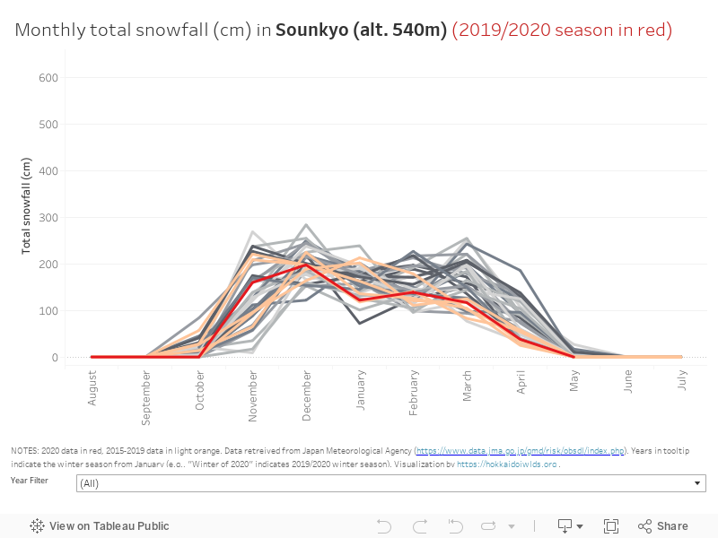
2.2b SNOWFALL | Monthly total snowfall – Historical Trends
Interestingly, while there seems to be no statistically significant change in snowpack depth in these higher locales, three out of the four do show a statistically significant downward trend in snowfall totals.


3 thoughts on “Hokkaido 2019/2020 Winter Snowfall and Snowpack Statistics”
Amazing job compiling all of this data into a very easy-to-understand format. Lots to consider for sure. The total cumulative annual snowfalls in Kutchan are particularly worrying. Seems like after the turn of the millennium the snowfalls have just plummeted. Historically averaging close to 15m in the town, now more like 10m (though all of the tourism websites will still state 15m), and dropping. Here’s to hoping we can turn that around for the next generation!
Your data here is all out I’m afraid.
It said 7 minutes reading time and here I am an hour and a half later…
Great read, fascinating data / insights
That reading time plug-in needs work, methinks! Many thanks for the kind words Jon.