Posted on Aug 8, 2023
0

Posted on Aug 8, 2023

0 0
14km

Distance

0.5 day(s)

Time

3/5

Remoteness

2/5

Water clarity

5/10

Difficulty

Jun-Oct

Best season

GPX

KML

TOPO

GSI

Lake Akan 阿寒湖, within the Akan-Mashu National Park 阿寒摩周国立公園, is a pristine lake surrounded by dense primordial forest in eastern Hokkaido, Japan. The lake is home to rare marimo マリモ, a protected species of moss balls. The surrounding forest is untouched, the Oakan-dake volcano towers over the lake at the eastern end. It's unlikely you'll see anyone else paddling on this expansive, beautiful lake. You'll be sharing the shoreline with eagles, kingfishers, and native deer. The adjacent Akan-kohan Village 阿寒湖畔 has deep ties with the Ainu indigenous people of Hokkaido. It is one of Hokkaido's Ainu cultural hubs, with many opportunities to learn about this vibrant indigenous way of life and people.

We visited this route on Aug 14, 2022

Paddlers: Haidee and Saoka

Last updated Aug 11, 2023

Topomap

Route Map

Need to know details

Lake Details

This route is on Akan-ko (阿寒湖), or Akam in the Ainu indigenous language. The lake is a natural lake, about 6km wide and 5.5km long. It has a shoreline of 26km and a maximum depth of 45m (18m average). The lake is at 420m above sea level and water visibility is 5m.

Location

Lake Akan is in the far east of Hokkaido, about 4.5hrs (300km) east of Sapporo City. This paddling route on the lake starts just west of the small Akan-kohan Village on the southern shoreline of Lake Akan.

Put-in Location: Google Maps

The put-in for this Lake Akan paddling route is essentially the only public put-in on the lake for paddlers. It’s about 100m north of the Lake Akan tourist boat maintenance yards, here. There’s a narrow gravel road from the main road to a very picturesque coarse-sand beach with fantastic views east across the lake to Oakan-dake 雄阿寒岳 (1370m). There’s very limited parking at the put-in. Paddlers will typically park on the side of the gravel access road. It is possible, however, to drive onto the beach for loading/unloading of boats.

Take-out Location: Google Maps

This is an out-and-back loop trip (or circumnavigation), so you’ll be taking out on the same picturesque beach you put in at.

General notes

On the approach to Lake Akan, you’d be forgiven for thinking you’re driving deeper and deeper into the Hokkaido wilderness, with no prospect of escape – the forest is untouched, primordial, and beautiful. All of a sudden, however, you’ll be spat out of the cool, shady woods into a bustling tourist trap of a village – Akan-kohan Village 阿寒湖畔 – on the southern shoreline of the lake. Expect small shops selling Ainu trinkets and carvings, alongside colossal hotels. It’s a nice enough village to wander around though, and a great opportunity to get a glimpse into one of the main Ainu cultural hubs of Hokkaido.

  • Northeast access restrictions: Vessels (including paddlecraft) without permits are not permitted in Churui Bay チュウルイ湾 (location) nor Kinetanpe Bay キネタンペ湾 (location) in the far northeast corner of the lake. This is to protect endangered marimo moss-balls in the area (see Section 2-I 1 (1)/(2) of the Akan National Park Akan Area Management Plan). Note that while motorized vessels without permits are prohibited to enter the wider National Park Special Protection Zone 国立公園特別保護地区 in the northeast, this restriction does not apply to non-motorized vessels (see details here). See our topomap with zoning details here, and the official Ministry of Environment map here (high-resolution version here).
  • Southeast access restrictions: The large tourist ferry and sightseeing motorboats launch from multiple locations along the Akan-kohan Village shoreline here. In correspondence with the Ministry of Environment Lake Akan Management Office (location) and Akan Nature Center (location), we were informed that paddlecraft should avoid crossing tourist ferry routes during ferry operation hours (daily, 8am-5pm). Therefore, paddlers seeking to paddle the southern shoreline should do so before 8am or after 5pm – see our map with ferry routes here. Note that smaller sightseeing motorboats can be active from as early as 6am.
  • Paddlecraft on Lake Akan: It’s relatively rare to see paddlecraft on Lake Akan. While canoeing is encouraged on the lake (see Section 2-I 1 (2) of the Akan National Park Akan Area Management Plan), rules regarding where paddlecraft are allowed on the lake appear not to be well defined nor understood. Rules are certainly not well communicated; there are none made public online, and we had to call multiple agencies to understand dynamics on the lake. The SUPER FANTASTIC Lake Akan website, for example, appears not to assume independent paddlers on the lake. To avoid any misunderstandings, we advise to either just paddle the west and northwestern end of the lake, or if you’re keen to circumnavigate the lake, make sure to avoid the southern shoreline during ferry operating hours. At all times, paddlecraft should hug the shoreline.
  • Put-in location: As noted above, there’s only one put-in/take-out location on the lake for paddlecraft, on the beach just west of the tourist ferry boatyard. The gravel road along the northern shoreline is under the purview of the Maeda Ippoen Foundation, and requires a permit to use (see their map here, and permitting details here) – therefore, in an emergency, paddlers should not expect to escape from the lake anywhere but the southern shoreline.
  • Maeda Ippoen Foundation Forests: The forests on the northern, western and southern sides of the lake are managed by the Maeda Ippoen Foundation 前田一歩園財団, and require a permit to enter. The actual shoreline of the lake, however, is classified as National Forest 国有林, so it is possible and acceptable to land (i.e., take a break) on the beaches on the lake shoreline.
  • Chuirui Island: Churui Island チュウルイ島 at the northeastern corner of the lake is home to the Marimo Observation Center チュウルイ島 マリモ展示観察センター (location). The island is only accessible by tourist ferry or sightseeing motorboat, unfortunately. There’s nowhere for paddlers to land on the island – the jetty is for motorboat use only.
Route description

Completely above-board western loop paddle (up to 10km): Akan Nature Center advises paddlers to stick to the western half of the lake, in order to avoid encounters with gaudy motorboats, the incongruously large tourist ferry, and misunderstandings regarding paddlecraft rules on the lake. Put in at the beach at the southwestern end of the lake, and paddle northwest along the shoreline for about 1km. From the 1km point, you can either continue paddling along the shoreline, or cut across about 800m of open water to the northern shoreline. Yaitai-to Island ヤイタイ島 is an easy 200m from the shore, so is worth paddling out to. It’s possible to paddle another 3km northeast along the northern shoreline to near Churui-to Island チュウルイ島. Return the way you came, along the shoreline.

Full circumnavigation (26km): For a full 26km circumnavigation of the lake, we recommend putting in as early as possible – preferably no later than 5am – and paddling in a counter-clockwise direction around the lake. This will get the problematic southern shoreline out of the way early in the morning, avoiding encounters with sightseeing boats.

Route Timing
Trip time: 4hrs 0min

To avoid the throngs of tourist boats, we’d recommend starting as early as humanly possible on Lake Akan. In summer, the sun rises at 3:30am, so if possible we’d recommend getting on the water no later than 5am for the most restful, peaceful experience.

Transport

Public transport:

Bus: Lake Akan is accessible by public bus from Kushiro JR train station. The nearest bus stop to the put-in beach is Akanko Bus Center 阿寒湖バスセンター (location). Google Maps has up to date timetabling information. From the Akanko Bus Center it’s a 2km walk to the put-in beach (location).

Taxi: The local taxi company in Akan-kohan village is Akan Hire 阿寒ハイヤー (location | TEL: 0154-67-2921). Handy for if you get stranded somewhere along the southern shoreline, but you’ll still need to get yourself and boats to a main road.

By car: 

There is limited parking at the put-in beach (location). Paddlers will typically park on the side of the gravel access road, but make sure to park as far as possible to the side of the road so as to not block traffic. It is possible to drive onto the beach for loading/unloading.

Physical maps
Official Topo Map: Akanko (阿寒湖) – map no. NK-55-31-16-3

NOTE: The official 1/25000 topo map(s) above can be purchased for 350yen from Kinokuniya bookstore next to Sapporo Station or online (in Japanese).

route safety

While Lake Akan is not a huge lake, there is nonetheless plenty of fetch across the lake which will allow for some considerable waves if the wind is up. Escape options from the lake are very limited. The only shoreline accessible by vehicle is a small part of the southern side of the lake, so pay attention to the weather forecast to make sure you’ll have favourable conditions for the entirety. There are a lot of commercial sightseeing boats on the lake, including a couple of large ferries and lots of small motorboats shaped like missiles (don’t ask why…it’s peak 1990’s bubble economy aesthetic). There are also fishing boats active on the lake. These commercial vessels on the lake will not be expecting to see paddlers anywhere on the lake, particularly at the southeastern corner of the lake. Either avoid paddling the eastern end of the lake, or if you must, be out of the area before 8am. At all times, paddlers should strive to hug the shoreline to avoid powered vessels.

Weather forecast

Windy.com weather forecast for Akan-ko

CampSites

Akan-kohan Campground (阿寒湖畔キャンプ場)

A nicely forested campground with small shop and an <em>ashi-yu</em> onsen footbath. About 900m walk from the Lake Akan public beach (paddling put in) and a 500m walk to the Akan Kotan Ainu village (central Akan-kohan village).

Location: 43.43395 N / 144.08686 E | 999 yen per person | Open: May-Oct
Closest Onsen: Lake Akan Tsuruga Wings (あかん湖 鶴雅ウイングス) | 2500yen | 0.5km from campground
Onsen nearby

The onsen closest to the lake at Akan are comparatively expensive compared to other locations in Hokkaido, but the views are really quite incredible. Try the New Akan Hotel ニュー阿寒ホテル (location, 1,250yen) for great onsen and an amazing infinity onsen pool (mixed-gender). There’s also the swanky Tsuruga hotels, such as the Tsuruga Wings Hotel 鶴雅ウィングズホテル (location, 2500yen).

Extra Resources

For up-to-date information on paddling on and access to Lake Akan, drop in to the Akan-kohan Eco-museum Center 阿寒湖畔エコミュージアムセンター (location) at the eastern end of the Akan-kohan village.

Guide Options

Contact Akan Nature Center for guided canoe paddling trips on Lake Akan.

Support us

Like this content? Buy the HokkaidoWilds.org team a coffee. 50% of tips go to the Hokkaido Wilds Foundation.

Show Full Route Notes Close Route Notes

Route Trip Notes

Our first paddling trip on Lake Akan was beautiful, confusing, and gloriously ignorant all at the same time. To start, I didn’t have any information about where paddlers could put in on the lake. That was not for want of trying. I called the Akan information center. “We’re not sure,” they said. “People don’t really paddle much on Lake Akan.”

Google Searches came up blank. 

It really did seem, as incredulous as it was, that almost no one ever paddled on Lake Akan.

It just didn’t make sense.

So, with very little information to go on, I decided to act on the little knowledge I did have of Lake Akan. 

“There’s a spot close to one of the outlets at the eastern side of the lake that you can get right to the water,” I explained with feigned confidence to Haidee and Saoka. “It’s right next to the Oakan-dake hiking trailhead, so there’s a car park there too.”

So it happened that we ended up putting in at the very eastern-most end of the lake, at around 7am, blissfully unaware that we would spend the next few hours hugging the shoreline, keeping out of the way of the alarmingly frequent, alarmingly gigantic, and alarmingly fast tourist boats that would cruise into even the most sacred-feeling nooks and crannies of the otherwise peaceful eastern reaches of the lake.

As we were paddling in the beautifully remote-feeling southeastern corner of the lake, we had one crew member on one of the larger ferry-like vessels cross his arms in an ‘X’ formation at us, which made us wonder if actually we weren’t supposed to be where we were.

Once we were in cell reception range on the lake, from my kayak I called around a few more information centers in Akan village, as well as the Akan-ko Nature Center.

“There’s no map that shows the off-limits areas,” the representative at Akan Nature Cetner told us. “And there’s nothing in writing about crossing the cruise boat float paths. However, generally, it’s not acceptable to cross the float paths, so it’s not possible even for us, an official canoe tour outfit, to paddle the eastern side of the lake,” he said apologetically.

Suffice it to say, the 15-minute quiet times between speedboat arrivals were a beautiful, calm, quiet oasis at the eastern end of the lake. Replete with flowers, deep forests, and white-tailed eagles.

We carried on, and paddled the majority of the eastern and northern shorelines of the lake, including the remote northeastern corner of the lake.

It was all very beautiful. Native ezo deer on the shoreline. A quiet facility of some sort. No tourist boats.

Once we made it a bit further around the lake, I spent a few more minutes scouring the web on my smartphone for more information about where it was OK to paddle on Lake Akan.

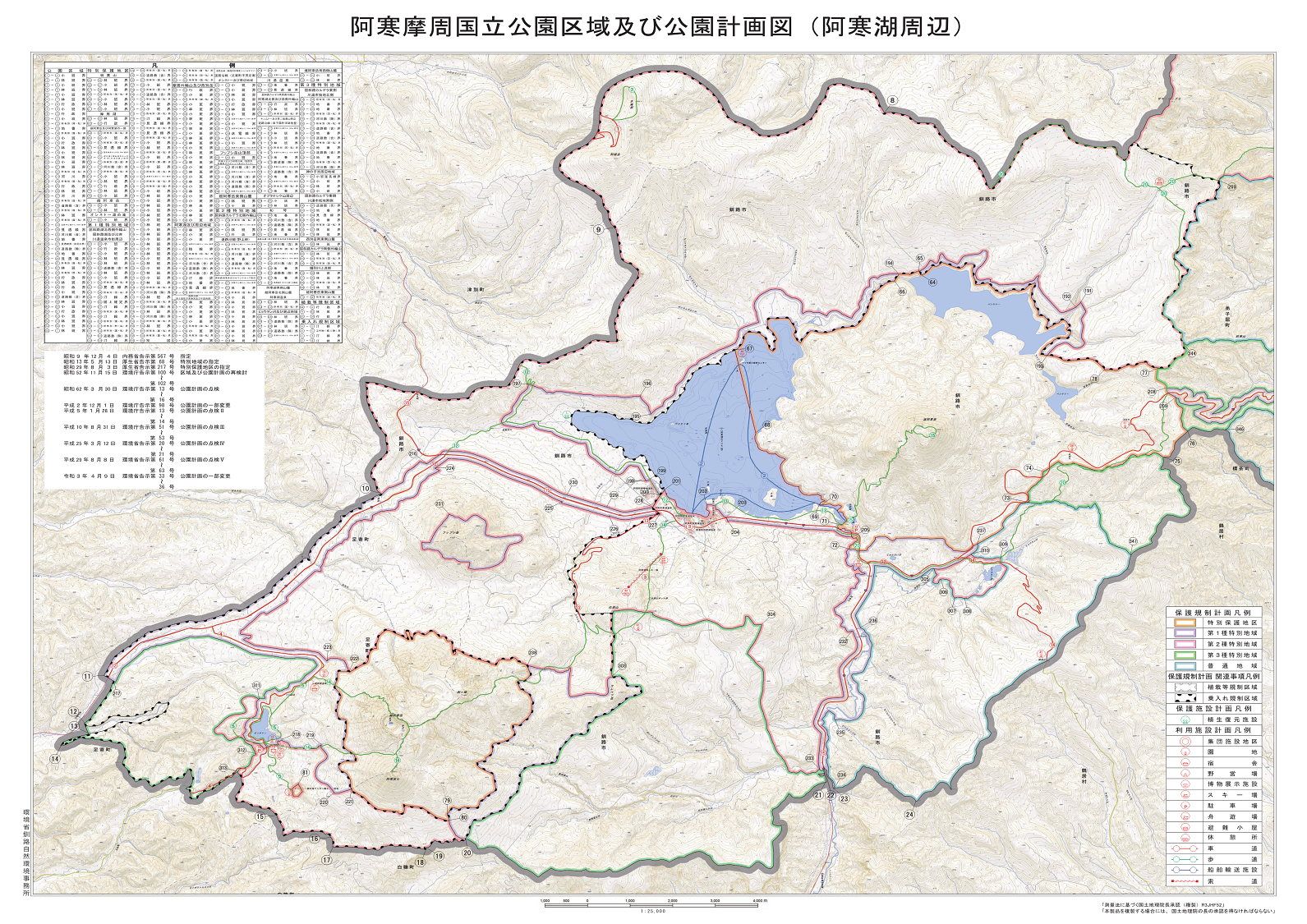
It was then when I came upon a map by the Ministry of Environment, below. It showed quite clearly where the ferry routes were. Based on this map, it appeared that the only way we’d get back to our put in where our car was, was to paddle all the way back around the lake, in the opposite direction.

So I called the Akan Nature Center again, and explained our situation in more depth, including where we’d ignorantly put in at the far southeastern corner of the lake.

“You shouldn’t have put in there, sorry. You’ll need to take out at the only legitimate take out on the lake,” the representative told me. “It’s just northwest of the tourist ferry boatyard.”

So it happened that we ended up finishing our paddle about 8km sooner than expected, but at least we finished it at a legitimate spot to take our boats out of the lake. As a put-in/take-out, it was perfect. A nice sandy beach, good vehicle access, amazing views. It felt strange that there wasn’t more information about this location on the web. We can only assume that the vast bulk of people visiting Lake Akan come to simply look at the lake (which as a goal in itself is a worthy one!).

Fortunately, I was able to call a taxi to take me from the take-out back to the car.

A few months after our paddle on Lake Akan, I started to email a few other agencies on the lake. I was keen to find out more about rules, restrictions and considerations for paddlers on the lake.

After a number of emails going back and forward with the Ministry of Environment Lake Akan Management Office, in the end it became clear that:

  1. It’s OK for paddlecraft to paddle in the Special Protection Zone at the northeastern end of the lake – only motorized vessels are prohibited.
  2. Unauthorized vessels (including paddlecraft) are not allowed in Churui and Kinetanpe Bays, as per the Lake Akan Management Plan.
  3. Paddlecraft should avoid paddling across ferry routes*, and should take care to keep watch for sightseeing boats and fishing boats.
    *When I asked about hours outside of ferry operation, the ranger said he didn’t see an issue with out-of-hours paddling.

To get to this point in understanding, it took a lot of back-and-forward. First, on the phone, the very helpful Ministry of Environment ranger at the Akan Management Office said that all vessels, including paddlecraft, were not allowed in the Special Protection Zone, due to concern over wake impacting marimo moss-ball colonies on the shoreline of the lake. Then, after asking about why non-powered vessels were not mentioned in the Ministry of Environment directives about the Special Protection Zone, to the officer’s credit he spent a few days finding out what was going on. It was after his few days of fact-finding that he amended his advice to paddlecraft being able to paddle in the Special Protection Zone, but not in the Churui and Kinetanpe Bays.

I mention this process of back-and-forward with an official agency simply to show that understanding about where paddlecraft can and cannot paddle on Lake Akan appears to be very blurry and ambiguous, even while government advice appears to be fairly black and white (in obscure documents that are difficult to find).

There may indeed be other local “rules” and preferences around paddlecraft on Lake Akan. Many of these rules and preferences seem to be quite unknowable without extensive surveying of a lot of institutions, companies, and agencies involved in the lake.

At this point, it appears that if paddlers just keep to the western end of the lake, there’ll be no issues whatsoever.

If paddlers must circumnavigate the lake, it appears the least worst option is to make sure to smash out the southern shoreline before around 6am if possible, and certainly before 8am when the ferry starts operation.

Comments | Queries | Reports

Done this route to Akan-ko, or other waterways nearby? Thinking of doing it? Please post any feedback, reports, or queries here. Thanks!

Leave a Reply

Your email address will not be published. Required fields are marked *

This site uses Akismet to reduce spam. Learn how your comment data is processed.

See More Like this

TOPO DOWNLOAD (PDF, 8.9MB)

Download may take some time

Hokkaido Wilds Foundation

We’ve got affiliate links on HokkaidoWilds.org to help fund the Hokkaido Wilds foundation.

The Foundation gets a small commission on sales from affiliate links, but we only link to stuff we think is worth checking out for people keen on the outdoors in Hokkaido and Japan.

The Hokkaido Wilds Foundation is a fund where 100% of funds are donated to Hokkaido volunteer groups involved in sustainable, safe, and responsible access to the Hokkaido outdoors.

Learn more here

ADVANCED FILTERS

Filter by location

About Filters

REGION: The general mountain/geographical region the route is in.

BEST MONTH(S): Time of year a route is suited to visiting. Some pop all season, some are more limited.

DIFFICULTY: How strenuous a route is, and how technical it is. Full details here.

FREERIDE/SKITOUR: Very subjective, but is a route more-of-a-walk-than-a-ski or the other way around? Some routes are all about the screaming downhill (freeride), some are more about the hunt for a peak or nice forest (ski-tour). Some are in between. 

MAIN ASPECT: Which cardinal direction the primary consequential slope is facing, that you might encounter on the route. More details here.

ROUTE TAGS: An eclectic picking of other categories that routes might belong to.

SEARCH BY LOCATION: You can find routes near your current location – just click on the crosshairs (). You may need to give permission to HokkaidoWilds.org to know your GPS location (don’t worry, we won’t track you). Or, type in a destination, such as Niseko or Sapporo or Asahikawa etc.

Please let us know how we can make it easier to narrow down your search. Contact Rob at rob@hokkaidowilds.org with your suggestions.

Lake Akan Difficulty Rating

Category

Grade

Points

Strenuousness

Vertical Gain

D

25

Time ascending

D

0

Technicality

Altitude

D

0

Hazards

D

Navigation

D

Totals

25/100

GRADES range from A (very difficult) to D (easy). Hazards include exposure to avalanche and fall risk. More details here. Rating rubric adapted from Hokkaido Yukiyama Guidebook 北海道雪山ガイド.