Lake Toya Center Island from Nakatoya Campground

洞爺湖 | To-Ya

Posted on Jul 3, 2019
2

Posted on Jul 3, 2019

0 2
18km

Distance

1 day(s)

Time

3/5

Remoteness

4/5

Water clarity

7.5/10

Difficulty

May-Oct

Best season

NOTE: On a clear, calm day, Lake Toya is a stunning place for an easy-going paddle. However, the lake can transform quickly even with moderate wind.

Please take note of the Lake Toya rules, here). Lake Toya (洞爺湖) is an expansive caldera lake with a beautiful central island (Nakajima Island 中島) that begs to be explored by canoe. It involves a long 4.5km paddle across open water to get to the island - which should not be underestimated - but the island itself offers birdwatching opportunities and a network of hiking trails. The lake itself is very clear, so paddlers will be treated to some gorgeous shore-side paddling around to the main inlet on the island's southern side.

We visited this route on Jun 09, 2019

Thanks to Chris J. T. Auld for the drone shots and video. Extra photos by Haidee Thomson.

Last updated Jun 24, 2022

Route Map

Need to know details

Lake Details

This route is on Lake Toya (洞爺湖), or To-Ya in the Ainu indigenous language. The lake is a natural lake, about 10km wide and 10km long. It has a shoreline of 36km and a maximum depth of 179m (117m average). The lake is at 84m above sea level and water visibility is 17m.

Location

The put-in location for this trip is at the Nakatoya Campground, here, on the eastern side of Lake Toya, about 60km southwest of Sapporo City. Canoes are only allowed to be put in from the eastern auto-camp section of the campground, around here, east of the O-River (大川).

General notes

The center island on Lake Toya has about 2-3hrs worth of hiking trails, along with a ferry landing, small shop, toilets, and a nature museum (200yen for entry). Making the trek to the island by paddle-craft is a very rewarding endeavour, and is great for fit, strong paddlers.

Like most lakes, the wind generally picks up during the day on Lake Toya as the air temperature rises and creates pressure differences due to the colder surface of the lake. Therefore, even if the forecast is for calm weather all day, if you’re planning to head to the center island, make it a very early start – well before 6am is best. Most people will be doing this trip in the summer months, so this early start shouldn’t be a problem – the sun will be up at around 4am anyway.

There are a number of campgrounds on the Lake Toya shoreline: Nakatoya Campground (east), Mizube-no-Sato Campground (north), Akebono Campground (north), Ko-Koen Campground (north), and Greenstay Autocamp (west). If you’re going to make this an overnight trip, staying at one of the campgrounds, take into consideration the forecasted wind direction when making a choice. The Nakatoya Campground has the most trees, however, so it’s our pick of the bunch, all other things considered.

Route description

Launch from the Nakatoya Campgound, and head straight for the island. The island looks closer than it is, and you’ll wonder it if isn’t actually moving away from you as you paddle. After about an hour of effort, you’ll arrive in a gorgeous small bay, which is a perfect spot for a break. From this bay it is 3km to the main settlement on the southern side of the island via the gorgeous eastern/southern shorelines. At the settlement there’s a small shop, toilets, and the start of a walking trail. For the return paddle, crossing the ferry path is strictly prohibited due to safety concerns; after having a walk on the island, return to the eastside bay back the way you came via the southern/eastern shoreline.

Route Timing
Trip time: 6hrs 0min

In total, including a short wander around the tiny settlement on the island, expect to spend about 6 hours for this full route. On a calm day with no wind, expect about one hour of paddling from Nakatoya Campground to the inlet on the eastern side of Naka-jima Island. Allow two full hours return from the inlet to the settlement; about 8km return around the east/south shoreline.

Transport

Public transport:

The Nakatoya Campground is accessible by bus from Sapporo JR Station, via the Toya Mizu-no-Eki (洞爺水の駅). Your best bet would be to ask at the station information center for up to date information, but as of June 2019, there were direct buses leaving at 10:10am, 2:10pm, 4:10pm, and 5:10pm (source) to Toya Mizu-no-Eki Bus Stop (洞爺水の駅バス停, around here), a trip of about 2.5 hours. From this bus stop, there is a local bus service running to the Higashi-nakatoya Bus Stop (東仲洞爺バス停, here) next to the Nakatoya Campground, three times a day. Ask at the Mizu-no-Eki for an up to date timetable, but as of June 2019, there were buses going at 6:55am, 1:32pm, and 5:30pm (only on weekdays).

By car: 

There is plenty of parking in the Nakatoya Campground carpark, here. If you’re camping at the Nakatoya Campground, then cars can be parked in the Dai-2 (Second) camping area, just east of the O River (大川), here.

Physical maps
Official Topo Map: Naka-toya (仲洞爺) – map no. NK-54-21-1-1
Official Topo Map 2: Toya (洞爺) – map no. NK-54-21-1-3

NOTE: The official 1/25000 topo map(s) above can be purchased for 350yen from Kinokuniya bookstore next to Sapporo Station or online (in Japanese).

route safety

Lake Toya is a very large lake by Hokkaido standards, and very exposed to the wind. If your plans involve visiting the center lake, consult the weather before setting off. This route in particular involves crossing 4.5km of open water, so is preferably attempted in teams of two or more boats, all with flotation bags, with a strong, experienced paddler in each boat. If caught out in windy conditions, play it safe and paddle downwind to the nearest shore. Landing is possible everywhere on the entire lake shore, and there is a perimeter road around the entire island, where one could hitch back to the put-in location.

Weather forecast

Windy.com weather forecast for Lake Toya

CampSites

Nakatoya Campground (仲洞爺キャンプ場)
Nakatoya Campgound is a large, tree-covered campground located on the eastern side of Lake Toya, on the very opposite side of the lake to the Lake Toya village. There’s an onsen right next to the campground. There’s two sections to the campground – a pedestrian-only section with parking over the road, and a smaller auto-camp section where cars can be driven to campsites. Canoes and kayaks can only be launched from the shoreline adjacent to the autocamp section. Both sections cost the same. Location: 42.61179 N / 140.91708 E | 450 yen per person | Open: May-Oct | Staff hours: 9:00am till 5:00pm.
Closest Onsen: Nakatoya Onsen (仲洞爺温泉) | 420yen | 0.2km from campground
Onsen nearby

This route starts and finishes at the Nakatoya Campground – there’s the Nakatoya Onsen (仲洞爺温泉, 420yen) just across the road, here.

Extra Resources

See the write-up in Tamada (1993), on p. 10-13 (in Japanese), ISBN4-89363-684-7.

Guide Options

If you’d like to hire a guide to show you around this area of Lake Shikotsu, then consider either the friendly team of experienced guides from Guide House Canoa (Canadian canoes) or Fumiaki Sakai from Ohtaki Outdoor Adventures (kayaks).

Support us

Like this content? Buy the HokkaidoWilds.org team a coffee. 50% of tips go to the Hokkaido Wilds Foundation.

Show Full Route Notes Close Route Notes

Route Trip Notes

UPDATE (May 6th 2021): Please note that it’s technically impossible to paddle the entire way around Nakajima Island, due to the commercial ferry route – no public watercraft are allowed to cross or enter the public ferry path. We weren’t aware of this when we did this trip. To be honest, the southwestern/western side of the island is not as nice as the southeast/east/north side anyway, so if we were to do the trip again, we’d just paddle around to the southern landing point (around the eastern side of the island) and return the same way.

We arrived at the Nakatoya Campground the night before, after completing a half-day paddle around the remote western reaches of Lake Shikotsu (route here). It was a gorgeous night that evening, with hardly a breath of wind. Perfect for splashing about in the canoes just meters away from our lake-side campsite.

The next morning broke equally as calm, with low cloud but hardly a breath of wind. The forecast was for this weather till at least 3pm, but we decided to make the most of the morning calm. I cooked up a quick breakfast of eggs and sausages, which would have to power us for most of the morning. Ahead of us was at least 3 hours of paddling, more if we ended up paddling around the island – which of course we did!

When we set off, the lake had some small ripples on the surface. About 30 minutes into our paddle towards the central island, the lake had transformed to a mirror. It was almost eerie how calm it was. Unlike Lake Shikotsu, which has almost a constant hum of traffic noise from the roads around the lake, Lake Toya was eerily quiet.

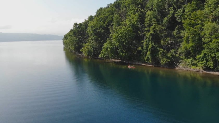
It took us pretty much bang on one hour to paddle the 4.5km from the Nakatoya Campground to the central island of Lake Toya. We approached the large inlet. immediately feeling surrounded by forest and alone. Very Jurassic Park vibes. Chris had his drone with him, so he and Saoka pulled onto the shore, where Chris set up the drone. He would capture some great photos and video.

We decided to push on to the main ferry landing point on the island, some 3.5km away around the island’s coast. We could hardly have asked for better paddling conditions. The sun was out, the water was clear, and the surface was calm. Every now and then we’d spook exotic looking ducks and other birdlife.

We arrived at the main inlet at around 10am. As we pulled onto the beach, one of the curious tourist ferries bumbled up to the jetty. It was a somewhat jarring sight, after spending the last few hours paddling with hardly and other watercraft around, let alone any with turrets and cheerful jingles playing from loud-speakers. This was the first time any of us had been to the island. We all felt chuffed at having made our first trip here under our own steam.

We had most of the day ahead of us, so we decided to to one of the very short walks on the island – just a half-hour wander around the lower part of the forest behind the museum. Once again it all felt very Jurassic Park, with high fences and solid gates. All to keep the deer out of the humans’ domain at the jetty. Apparently there is quite a large population of deer on the island – we didn’t see any.

With our short walk complete, it wasn’t even 11am. But we’d been active for almost 5 hours by now, so we sat down at the small restaurant at the bay area and had soba noodles. We’d need the energy for the long slog ahead of us around the windward side of the island. If we’d wanted it, we could have had a full meal of Hokkaido-style Genghis Khan hotplate lamb.

Over lunch, we had a discussion as to whether we should carry on around the island or not. It would add at least 2km (30mins) to the trip, and we knew that blustery weather was forecast for later in the afternoon. Should we carry on or take the more conservative option?

In the end, we decided we’d come all this way, and we may as well push on around the island for a full circumnavigation. So we set out from the idyllic bay, and made our way around the northwestern side of the island, avoiding the ferry as we went.

I didn’t take any more photos for at least an hour. This was not because there was nothing to take photos of, but more that I was more concentrating on keeping our boat from capsizing.

As we rounded the northwestern side of the island, we were treated to a brisk northwesterly which whipped up some considerable waves, some requiring turning the boat directly into them. As we powered our way around the island however, the wind did, of course, turn into a glorious tailwind with a beautiful following sea. We were flying now. 

After almost two hours of good solid effort, including watching out for an increasing number of wakeboarding boats, we pulled into a nice fine pebble beach. It was a very nice reprieve from the relative stress of this north and northeastern side of the island.

From here, we’d make our beeline across 4.5km of open water from the island back to the campground. At least we had the prevailing wind at our backs, and we now appeared to be out of the speedboat area. The paddle back was uneventful, apart from once again being treated to some absolutely gorgeous mirror-like water conditions nearer to the campground.

Back at the campground, some of our campsite neighbors were out paddling, trying out each other’s canoes. There was an old Mad River Explorer 16′ (for sale for 120,000yen, completely rotted out gunwales and all), an Ally 15′ folding canoe, and a two-person Arfeq folding kayak (domestic Japan outdoor brand Montbell’s canoe brand). Chris and I had a go in the Ally, but weren’t 100% convinced. Perhaps a 16′ version would be more practical…

As soon as we got off the lake and started packing up the campsite, the forecast afternoon winds picked up as if on cue. In a matter of minutes, the once glass-smooth lake turned into a choppy mess. We were glad we’d finished up our trip when we did.

We got the canoes tied down on top of Chris’s car, one on top of the other, precariously as ever, and got on our way. A day well lived.

Comments | Queries | Reports

Done this route to Lake Toya, or other waterways nearby? Thinking of doing it? Please post any feedback, reports, or queries here. Thanks!

2 thoughts on “Lake Toya Center Island from Nakatoya Campground”

  1. thank you for your detailed explanations. What do you think about reaching central island by SUP paddling? impossible?

    1. Anything is possible if you’re fit and strong enough, and the weather is good 😉 To the island and back, for most fit SUPers, at an average pace, would take at least two hours (return, with no breaks). So, my advice would be to make sure you’re confident of being able to paddle for that amount of time, and make sure you have a very clam weather window of at least double that time, in case anything goes wrong.

Leave a Reply to Dalai Cancel reply

Your email address will not be published. Required fields are marked *

This site uses Akismet to reduce spam. Learn how your comment data is processed.

See More Like this

TOPO DOWNLOAD (PDF, 6.2MB)

Download may take some time

Hokkaido Wilds Foundation

We’ve got affiliate links on HokkaidoWilds.org to help fund the Hokkaido Wilds foundation.

The Foundation gets a small commission on sales from affiliate links, but we only link to stuff we think is worth checking out for people keen on the outdoors in Hokkaido and Japan.

The Hokkaido Wilds Foundation is a fund where 100% of funds are donated to Hokkaido volunteer groups involved in sustainable, safe, and responsible access to the Hokkaido outdoors.

Learn more here

ADVANCED FILTERS

Filter by location

About Filters

REGION: The general mountain/geographical region the route is in.

BEST MONTH(S): Time of year a route is suited to visiting. Some pop all season, some are more limited.

DIFFICULTY: How strenuous a route is, and how technical it is. Full details here.

FREERIDE/SKITOUR: Very subjective, but is a route more-of-a-walk-than-a-ski or the other way around? Some routes are all about the screaming downhill (freeride), some are more about the hunt for a peak or nice forest (ski-tour). Some are in between. 

MAIN ASPECT: Which cardinal direction the primary consequential slope is facing, that you might encounter on the route. More details here.

ROUTE TAGS: An eclectic picking of other categories that routes might belong to.

SEARCH BY LOCATION: You can find routes near your current location – just click on the crosshairs (). You may need to give permission to HokkaidoWilds.org to know your GPS location (don’t worry, we won’t track you). Or, type in a destination, such as Niseko or Sapporo or Asahikawa etc.

Please let us know how we can make it easier to narrow down your search. Contact Rob at rob@hokkaidowilds.org with your suggestions.

Lake Toya Center Island from Nakatoya Campground Difficulty Rating

Category

Grade

Points

Strenuousness

Vertical Gain

D

25

Time ascending

D

0

Technicality

Altitude

D

0

Hazards

D

Navigation

D

Totals

25/100

GRADES range from A (very difficult) to D (easy). Hazards include exposure to avalanche and fall risk. More details here. Rating rubric adapted from Hokkaido Yukiyama Guidebook 北海道雪山ガイド.