Lake Toya Zero Point Canoeing (Suichu-jima)

洞爺湖ゼロポイント | To-Ya

Posted on Jul 30, 2021
0

Posted on Jul 30, 2021

0 0
6km

Distance

0.5 day(s)

Time

4/5

Remoteness

4/5

Water clarity

7.5/10

Difficulty

Jun-Sep

Best season

GPX

KML

TOPO

GSI

CAUTION: Lake Toya is a notoriously dangerous lake. Wind conditions don’t always follow local weather forecasts. Any open water paddlers on Lake Toya in calm conditions must assume they’re paddling on borrowed time. If it’s calm when you set off, don’t assume it will stay that way. Paddlers must be proficient at self-rescue. See the Lake Toya Canoe/SUP rules here.

The Lake Toya Zero Point 洞爺湖ゼロポイント is a shallow (≈1m) reef-like underwater island curiously surrounded by open water, about 700m off the shore of the lake's central island. Also referred to as the Suichu-jima 水中島 - literally, Underwater Island - this approximately 30m² underwater rocky mound is surrounded by lake depths of up to 180m. Technically it's essentially a fifth volcanic island in the middle of the caldera expanse that is Lake Toya. The lake's ultra-clear water means this is a worthy destination for experienced open-water paddlers on a calm day. Enjoy the spooky delight of suddenly paddling in 1m of water, still far from the shores of Nakajima Island.

We visited this route on Jul 25, 2021

Topomap

Route Map

Need to know details

Lake Details

This route is on Lake Toya (洞爺湖ゼロポイント), or To-Ya in the Ainu indigenous language. The lake is a natural lake, about 10km wide and 10km long. It has a shoreline of 36km and a maximum depth of 179m (117m average). The lake is at 84m above sea level and water visibility is 17m.

Location

Lake Toya is in southern Hokkaido, about 2 hours drive southwest of Sapporo City, or one hour drive south of the international resort of Niseko. This Lake Toya Zero Point (also referred to as Suichu-jima 水中島, location) is about 750m northeast off the shore of Lake Toya’s central island (Nakajima 中島), here.

Put-in locations: There are plenty of locations to access the Lake Toya shoreline, but places to park a car are limited. For the Lake Toya Zero Point, the closest official put-in points with parking are the two options below. They’re both a similar distance from the Zero Point in terms of as-the-crow-flies distance.

  • Lakehouse at Toyako: This gorgeous private estate with a luxury guesthouse, camping, and equipment rental, has an easy-access lake access point, here. They charge 1,000yen per person for access to the estate and parking. Entrance fee is waived if you plan on staying at the guesthouse, camping or renting equipment. If you’re keen to escape the madding crowds of the Takarada Campground next door, this is a very relaxing, highly recommended option. Their basic camping area is 1,500yen per person per night.
  • Takarada Campground: Very popular and busy on the weekends, this sprawling campground offers day-visitor access for 500yen per person, plus 400yen per vehicle for parking (location). Access to the lakefront is a bit of a walk from the car parking area.


General notes

Lake Toya is a volcanic caldera lake in the Shikotsu-Toya National Park in southern Hokkaido. It ranks in the Japan national “100 most beautiful places” 日本百景, and was the location for the 2008 G8 summit. As a paddling destination, it is well known for its central island and good accessibility via a quiet ring road around the lake. The central island tends to be a magnet for paddlers, and is worthy as a destination in its own right (see our route overview here). Less known is the small reef-like underwater prominence about 700m off the shore of the central island. Depending on the lake level, the shallowest point is around 1m deep. Given the clarity of the lake, the underwater mound is nicely visible once you’re on top of it – especially so when the lake is mirror-calm – usually in the early morning.

  • When to paddle: To make the most of seeing this peculiar underwater mound, we highly recommend paddling just after dawn, when the sun is low in the sky. This allows the light to enter the water at a low angle, illuminating the underwater rocks nicely. This time of day is usually the most calm too.
  • Weather forecast: For the most reliable wind forecast, we use Windy.com. Generally, we find that the gust forecast is usually the better indicator for actual consistent wind conditions on Lake Toya. Generally we only head out into open water on Lake Toya if it’s forecast to gust less than 20km/h (10kt) at the most during the day.
  • Canoe/SUP/kayak rental: Lakehouse at Toyako is the only place around Lake Toya that rents out paddlesports equipment. See their prices on their website here. Includes lifejackets and basic safety instruction.
Route description

The closest official launching spot to the Zero Point is the Lakehouse at Toyako, here. You can also launch from the Takarada Campgound next door, but you may need to carry your canoe for a further distance from the carpark. From the Lakehouse at Toyako, head roughly on a southern bearing, veering to the south-southeast. After 2.8km or so of paddling (about 45min to an hour), you’ll be at the Zero Point, about 700m before you get to the Nakajima Island. Note, however, that you can’t see the underwater mound until you’re right on top of it. There’s nothing on the surface of the water that would give it away. No buoys, ripples, or changes in the water surface. So, you’ll need to use your GPS for this one. Return the way you came, or, if Windy.com is forecasting less than 20km/h (10kt) maximum wind gusts during the day, then consider paddling on another 700m to the central island. Return the way you came.

Route Timing
Trip time: 2hrs 30min

This open-water paddling route will take at least 2hrs return from The Lakehouse at Toyako, plus a bit more time to enjoy the shallow water at the Zero Point.

Transport

Public transport:

There’s public buses that runs around the circumference of Lake Toya. For access to the Lakehouse at Toyako or Takarada Campground, catch the Donan Bus 道南バス from the Toyako-Onsen bus terminal 洞爺湖温泉 (location) and get off at either Takarada-bashi 財田橋 bus stop (location) or Takarada 財田 bus stop (location). Google Maps has good public transport directions, timetables, and fare information. The Toyako Onsen bus terminal is accessible by public bus from Sapporo City (about 3hrs).

By car: 

There are a number of car parking areas around Lake Toya – some are free, some cost money to access (around 500 yen per day). For this route, you’ll likely want to park either at the Lakehouse at Toyako (1,000yen per person for one day parking), or Takarada Campground (500yen per person, plus 400yen per car).

Physical maps
Official Topo Map: Toya (洞爺) – map no. NK-54-21-1-3

NOTE: The official 1/25000 topo map(s) above can be purchased for 350yen from Kinokuniya bookstore next to Sapporo Station or online (in Japanese).

route safety

Lake Toya is one of the most notorious lakes in Hokkaido – rescues happen on a weekly, if not daily basis in the high summer months. It’s a large lake with huge fetch. That is, wind has about 10km of water surface to blow over, which results in higher waves that one might otherwise expect. The lake can transform from a benign pond-like surface into a seriously dangerous ocean-bay-like environment with whitecap waves in a matter of minutes. Furthermore, such changes in lake surface can be unpredictable – wind conditions do not always follow weather forecasts for the wider local area. All paddlers heading out into the open waters of Lake Toya in calm conditions must assume they are on borrowed time – assume the lake will get rough at some point during the day, so make sure to be off the lake with plenty of time up your sleeve. Generally, paddlers will find the early morning (from dawn till about 3-4hrs after dawn) will be the most calm. Avoid planning to be on the lake in the middle of the day. Always wear a lifejacket, and carry some form of communication (smartphone in waterproof housing).

Weather forecast

Windy.com weather forecast for Lake Toya

CampSites

Lakehouse at Toyako Camping (レイクハウスアットトウヤコ )

Lakehouse at Toyako is a beautiful, sprawling private estate on the northern shores of Lake Toya. In addition to offering beds in the exclusive lakehouse, they also offer camping on their large lawns to the eastern end of the estate. This gives good access to the lakeshore. The estate offers a much more exclusive, less busy camping experience than the Takarada Campground next door. They also have canoes, SUPs and other equipment for hire.

Location: 42.64117 N / 140.85866 E | 1500 yen per tent | Open: Jan-Dec | Staff hours: 9:00am till 7:00pm.
Closest Onsen: Toya Ikoi-no-Ie (洞爺いこいの家) | 370yen | 4km from campground
Mizube-no-Sato Takarada Campground (水辺の里財田キャンプ場)
This is a relatively new, large campground, suitable for camping cars as well as single tents. It is one of the more well-appointed campground on Lake Toya, with laundry and coin showers in addition to all the other amenities you’d expect. Location: 42.64125 N / 140.85445 E | 800 yen per person | 1000 yen per tent site | Open: May-Oct | Staff hours: 8:00am till 8:00pm.
Closest Onsen: Toya Ikoi-no-Ie (洞爺いこいの家) | 370yen | 4km from campground
Onsen nearby

If it’s your first time at Lake Toya, we’d highly recommend making the drive to the other side of the lake for a soak in the Manseikaku Hotel onsen 万世閣ホテル (location, 1100yen). At 1,100yen per person it’s pretty pricey, but the 7th floor onsen is out of this world. With massive views across Lake Toya, it really is worth the effort and cost.

Extra Resources
No extra English resources that we know of. If you know of any, please let us know in the comments.

Guide Options

For an experienced English-speaking paddling guide, consider contacting Fumiaki Sakai from Ohtaki Outdoor Adventures.

Support us

Like this content? Buy the HokkaidoWilds.org team a coffee. 50% of tips go to the Hokkaido Wilds Foundation.

Show Full Route Notes Close Route Notes

Route Trip Notes

Haidee and I were at Chris‘s cabin in Rankoshi for the weekend. The cabin’s mighty canoe had been sitting unused for far too long, so we hauled it out and took it for a drive to Lake Toya.

We’d also been in sporadic contact with Jon, the owner of the Lakehouse at Toyako, and had been meaning to visit at some stage. Thus we ended up availing ourselves of their lakeside access via their sprawling private estate.

“We’ll be arriving at 5:30am, so we’ll try not to wake anyone,” I assured Jon via text message.

“Go ahead, no worries,” he replied. “I’ll see you later on.”

This was our first time visiting the Lakehouse at Toyako, and we were immediately impressed at the tucked-away-from-the-crowds feeling of the place. Whereas everywhere else we visited this four-day weekend was seething with people, the large estate here was an oasis of calm.

Despite the calm weather, I was feeling rushed as we got the canoe and gear together for the open-water paddle out to the reef. I always feel like we’re on borrowed time on Lake Toya. Early mornings are usually gorgeously calm, but by mid-morning, there’s often whitecaps out on the lake.

Today, we had gusts of 30km/h forecast for the middle of the day, with mostly calm conditions forecast till around 9:30am. It was now 6am, so in theory we had about 3 hours or so of good probability of calm conditions. One thing that we had going for us should we be out longer though, was the wind was forecast to blow from the south. If all turned to custard, at least we’d have a following sea on the way back to the Lakehouse.

We set off in the mighty blue canoe.

“This feels a big wobbly,” Haidee remarked.

It was our first time on a lake in this canoe, and indeed it felt different from our usual shallow-arch, stiff, high-spec Prospector 16ft by Novacraft. This was a fairly generic flat-bottom fiberglass canoe with a prominent keel. It tracked well, but the floor oil-cans (flexes) quite a bit more than our canoes. That said, we made fast progress across the very flat lake – averaging just under 6km/h. This was a quick boat.

Like last time when we paddled towards Lake Toya’s center island, we remarked to each other how deceptively far the island is. At just over 3km from the Lakehouse at Toyako, it’s a decently long time to be exposed to the risks of being so far from shore. We pointed the canoe on a heading that we figured should get us to the Zero Point, and just kept paddling.

After about 45 minutes, we paused to let me check the GPS.

Oops. We had overshot the Zero Point by about 100m.

With an eye on my phone now, we pointed the canoe northeast and started paddling the final short distance to where the lake should, in theory, suddenly start to get shallow.

It was a strange feeling. Spooky even. Great anticipation flooded us as we paddled slowly through nothing but deep, deep blue water. We’d just spent the last 45 minutes paddling a canoe above 180m of water. We were still at least 700m off the shore of the central island. How on earth could there be somewhere shallow enough to stand up in way out here.

I kept peering over the side of the canoe.

And then the water started to change color.

“There it is!” I exclaimed.

Sure enough, out of the murky blue water, shapes of rocks started to appear, distorted by long shafts of light piercing through the clear depths of the lake.

But it was still clearly way too deep to stand up in.

We carried on paddling slowly.

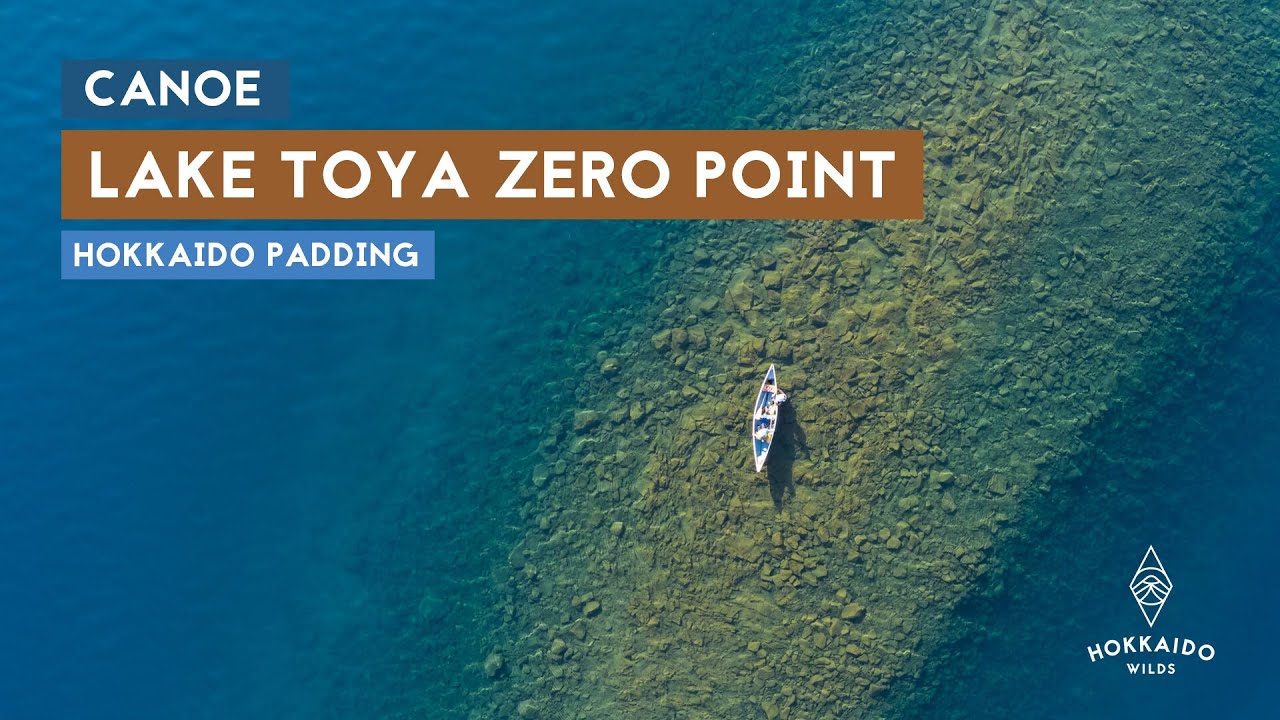
Curiously, it wasn’t the ‘topographical’ apex of the underwater contour lines that marked the shallowest spot. It was a spot perhaps 10m or so north of that spot.

Haidee reached down with her paddle and was surprised when the end of the blade hit the bottom with ease.

We’d made it to the famed Lake Toya Zero Point.

I was keen to get in and stand up in the middle of Lake Toya. Haidee braced and I slid into the water. 

Surprisingly warm, it was a nice temperature for a warm morning.

I sent up the drone.

Shallowest point confirmed.

If this whole submersed island wasn’t curious enough, the fish were curiouser still. At aquariums, there’ll sometimes be those cute little fish that will nibble at your skin when you put your hand or feet into water. Well, this spot was crawling with the critters. 

Haidee had also jumped in at this point. I clambered back into the canoe, and paddled off a ways to get some longer shots. It’s difficult to fully capture how incongruous this spot is, way out in the middle of the lake.

We spent about half an hour playing about in the area, and were starting to feel like it was time to head back to shore.

Borrowed time.

So Haidee clambered back into the canoe and we started the paddle back to the Lakehouse. The lake was mirror-calm.

By the time we got back, preparations were in full swing for the Lakehouse at Toyako’s weekend popup summer cafe. Satay chicken skewers, drinks, general good vibes. A slice of paradise with a side of awesome lake to go.

By the time we were ready to leave at around 10:30am, the forecasted southerly had started to blow, and the lake was getting into gear for the afternoon wave-fest. Whitecaps were starting to form. We’d made the most of the best of the day, and now the lake was just for paddling about close to shore.

The famous-on-the-internet Niseko Babu pooch was certainly making the most of the cool water.

Comments | Queries | Reports

Done this route to Lake Toya, or other waterways nearby? Thinking of doing it? Please post any feedback, reports, or queries here. Thanks!

Leave a Reply

Your email address will not be published. Required fields are marked *

This site uses Akismet to reduce spam. Learn how your comment data is processed.

See More Like this

TOPO DOWNLOAD (PDF, 5.5MB)

Download may take some time

Hokkaido Wilds Foundation

We’ve got affiliate links on HokkaidoWilds.org to help fund the Hokkaido Wilds foundation.

The Foundation gets a small commission on sales from affiliate links, but we only link to stuff we think is worth checking out for people keen on the outdoors in Hokkaido and Japan.

The Hokkaido Wilds Foundation is a fund where 100% of funds are donated to Hokkaido volunteer groups involved in sustainable, safe, and responsible access to the Hokkaido outdoors.

Learn more here

ADVANCED FILTERS

Filter by location

About Filters

REGION: The general mountain/geographical region the route is in.

BEST MONTH(S): Time of year a route is suited to visiting. Some pop all season, some are more limited.

DIFFICULTY: How strenuous a route is, and how technical it is. Full details here.

FREERIDE/SKITOUR: Very subjective, but is a route more-of-a-walk-than-a-ski or the other way around? Some routes are all about the screaming downhill (freeride), some are more about the hunt for a peak or nice forest (ski-tour). Some are in between. 

MAIN ASPECT: Which cardinal direction the primary consequential slope is facing, that you might encounter on the route. More details here.

ROUTE TAGS: An eclectic picking of other categories that routes might belong to.

SEARCH BY LOCATION: You can find routes near your current location – just click on the crosshairs (). You may need to give permission to HokkaidoWilds.org to know your GPS location (don’t worry, we won’t track you). Or, type in a destination, such as Niseko or Sapporo or Asahikawa etc.

Please let us know how we can make it easier to narrow down your search. Contact Rob at rob@hokkaidowilds.org with your suggestions.

Lake Toya Zero Point Canoeing (Suichu-jima) Difficulty Rating

Category

Grade

Points

Strenuousness

Vertical Gain

D

25

Time ascending

D

0

Technicality

Altitude

D

0

Hazards

D

Navigation

D

Totals

25/100

GRADES range from A (very difficult) to D (easy). Hazards include exposure to avalanche and fall risk. More details here. Rating rubric adapted from Hokkaido Yukiyama Guidebook 北海道雪山ガイド.