PREAMBLE
Between the 1st of November and 31st of March 2020 (five months) HokkaidoWilds.org as a whole received almost 150,000 page views, by over 37,000 individuals. That’s an extra 10,000 individuals and 35,000 page views more than the same period last year (Nov ’18 till Mar ’19).
Along with this increase in exposure – mostly through web search traffic – we’ve felt an increased sense of responsibility to continue being active in the wider Hokkaido outdoor scene. To that end, Rob has accepted an invitation to be part of the Hokkaido Outdoor Forum Steering Committee for 2020, and we continue to be involved in consultation to Hokkaido government agencies and NGOs.
At the same time, over the last five months, we’ve continued to pour effort into our three guiding principles of inspiration, information, and education.
KEY POINTS
NATIONAL AWARDS
At the Ministry of Land, Infrastructure, Transport and Tourism’s GEO Expo 2019 in Tokyo in November, HokkaidoWilds.org won two national awards for our English topographical GeoPDF maps.
OUTREACH
We gave a presentation at the Noboribetsu Outdoor Meeting, gave an avalanche awareness session in Singapore, and were scheduled to give a keynote address at a Ministry of Environment Symposium (cancelled due to COVID-19 issues).
ROUTE POSTS
We published 41 route overviews on the site, including 32 ski touring routes, five hiking routes, and three canoe routes.
POSTS ADDED OVER THE PAST FIVE MONTHS (from Nov 1st 2019 till Mar 31st 2020)
Ski Touring Routes
We documented a total of 32 ski touring routes and published them to the site over the past five months. The majority of them were routes outlined in the Hokkaido Yuki-yama Guidebook, published by Hokkaido Newspaper Press. Included in those 32 routes were a couple of routes in Aomori Prefecture at the north of Japan’s main island of Honshu, penned by Chris Auld. While our planned 9-day Tohoku documentation trip got rained out half way though, we were inspired by the potential of Honshu’s northern reaches for ski touring. The trip confirmed to us that Hokkaido as a destination is well-suited as a base to explore not only Hokkaido itself, but also regions surrounding this amazing island.
See all ski tour routes: https://hokkaidowilds.org/skitour

Hiking Routes
Rick Siddle and Rob Thomson began publishing a number of Akan-Mashu National Park and Shiretoko Peninsula hiking routes they documented in the autumn of 2019. Rick also continued to retrospectively write up route overviews of hikes he’d done in the past, before Hokkaido Wilds. Through discussions with Ministry of the Environment officials and NGO contacts over the past few months, it’s clear that the Hokkaido government wishes to push Hokkaido as a destination for hiking, particularly focused on national parks here.
See all the hiking routes here: https://hokkaidowilds.org/hike

Other Routes
We also managed to post three canoe routes, one just after the first snowfall of the season in Niseko! There is so much untapped potential for great canoe journeys in Hokkaido, so we’re really looking forward to documenting canoe routes as the weather warms up in 2020.
See all the canoe routes here: https://hokkaidowilds.org/water

Other Posts
Where possible, we’ve continued to dig into public data on a few different issues, including climate and Hokkaido Search and Rescue Incidents. Of particular concern this winter season was an unseasonably late snowfall (see the data here). Also making the news were a higher than usual number of backcountry fatalities involving foreigners. Analyses of search and rescue trends over the years paints a more nuanced picture, however. Our analysis of the last five years of Hokkaido Police Mountain Search and Rescue data was one of our single-most popular posts during this five month period, particularly the Japanese version (English version | Japanese version).

OTHER NOTABLE HAPPENINGS
NATIONAL AWARDS
- Ministry of Land, Infrastructure, Transport and Tourism GeoActivity Contest Awards
We were thrilled to have taken away two national awards at the annual Ministry of Land, Infrastructure, Transport and Tourism GeoActivity Contest in November 2019. We applied to present our work on printable and GeoPDF hiking, skiing, and canoeing topomaps earlier in 2019, and were happy just to be accepted to present our work. We joined 20 other groups (companies, organizations, individuals etc) all showcasing their utilization of the Geospacial Information Authority of Japan’s map data. The event was held at the Miraikan in Tokyo – The National Museum of Emerging Science and Innovation – HokkaidoWilds.org won the “People’s Choice Award (来場者賞)” and “Digital Map Data Practical Use Award (電子国土賞)”. See the full details here.


- Ministry of the Environment Commemorative Symposium (16th March 2020) Rob was invited to be the keynote speaker at a Ministry of the Environment Symposium to commemorate the re-organization of the Daisetsuzan National Park Council. See the PDF flyer here. Unfortunately, due to the coronavirus outbreak in Hokkaido, this was indefinitely postponed.
- Avalanche Awareness Session in Singapore (16th November 2019) Hokkaido Wilds’ author Chris Auld presented a primer on avalanche awareness at The Ride Side’s Feel the Stoke event in Singapore on Saturday the 16th of November at the Focus One building. The event was very well attended, and a crucial piece of outreach as Hokkaido sees more and more serious skiers and boarders visit from Singapore.
- Noboribetsu Outdoor Meeting (15th January 2020) At this small (30 people) gathering of outdoor professionals, guides, and related government officials, Rob presented a primer on using Japan government map data to create custom topographical maps for outdoor use. See the flyer here, and Rob’s slides here.
- Shikotsu-Toya National Park Hiking Trails Project Rob was consulted by Sapporo local planning company LIVE Environmental Planning, regarding specific hiking trails in the Shikotsu-Toya National Park, particularly around Lake Shikotsu.
- Ministry of the Environment Brochure Base Map Hokkaido Wilds was commissioned by a company producing a tourist brochure for a hike in the Daisetsuzan National Park, to create a multi-layer vector basemap (in Adobe Illustrator format) for use in the creation of the brochure. This work was a paid job, allowing us to replenish our operating funds (see finances section below).
GOALS FOR THE FUTURE
Our goals haven’t changed much since our last 1-year report in November 2019. As a refresher, on our overall mission statement document, we say “by 2025, our goal is to have written detailed online route overviews for the following in Hokkaido and surrounding areas: 150 ski touring routes, 120 hiking routes, 50 canoe routes, and 120 bikepacking/cycle touring routes.” Also, “our aim is for at least half of those routes to be multi-day routes.”
Below is our current progress towards those goals. We’re doing pretty well on the ski touring routes, and we hope to make some considerable headway on the hiking and canoe routes in particular this coming year.
Progress towards 2025 Goals
On the To-Do list
Our to-do list is, embarrassingly, largely unchanged from the list in November 2019.
- Update old printable topomaps - We launched the printable TOPOMAP+ A4 maps in March 2019. Posts prior to this only had rough Japanese-only printable maps extracted directly from the GSI web interface. And then in the first week of November 2019, we added GeoPDF functionality. We need to go back and update the 90 or so posts that don't have these maps available.
- Make the switch to WordPress 5.0 - We still haven't upgraded the site to Worpdress 5.0...this may or may not be a nightmare. Watch this space. For end users, this is not relevant.
- Set up a bank account - As per the point below, we've discovered we can register a bank account under a voluntary association status, so we're working on that now, with an official inkan seal on order as we write.
-
Set up non-profit incorporated association- Quite early on after launching the site, we mentioned that we wanted to set up a non-profit incorporated association (非営利型一般社団法人hieiri-gata ippan shadan hojin). One of the driving reasons for this was because we want to have some sort of legal financial structure to our endeavor togive away all revenue generated from the Hokkaido Wilds website. Recently, we've discovered we can register a bank account under a "voluntary association" structure, without formal registration as an incorporated association. Considering that a) the site has earned next to no direct revenue since launch and b) setting up an incorporated association costs at least US$1,000 equivalent, we're mothballing this incorporated association idea for now. We will revisit this stance in April 2021 in light of where we are then. Here's our official 'voluntary association' Terms of Operation here, if you're interested.
WEB ANALYTICS
Here’s some insight into HokkaidoWilds.org access numbers over the last five months.
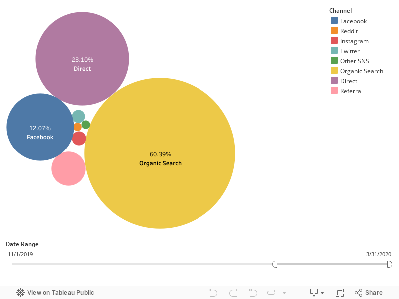
Website access by source
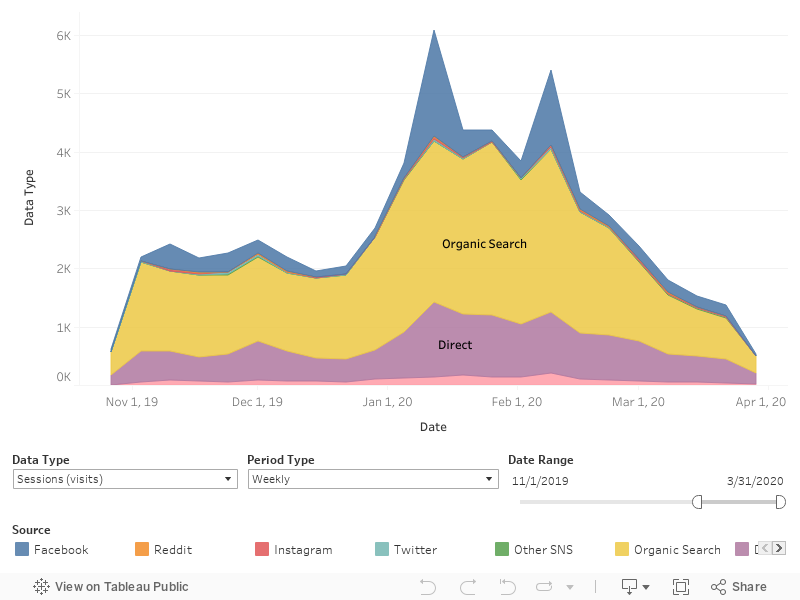
Sessions by source (Nov-Mar)
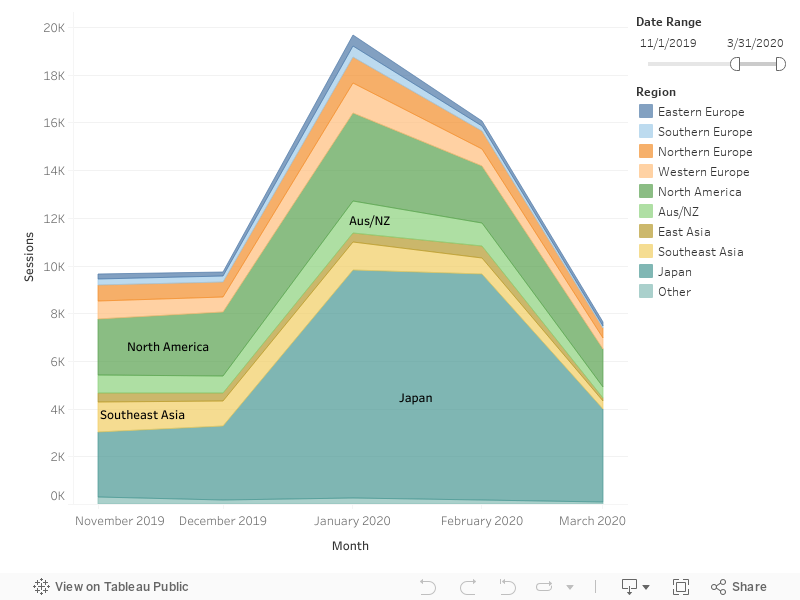
Sessions by region (Nov-Mar)
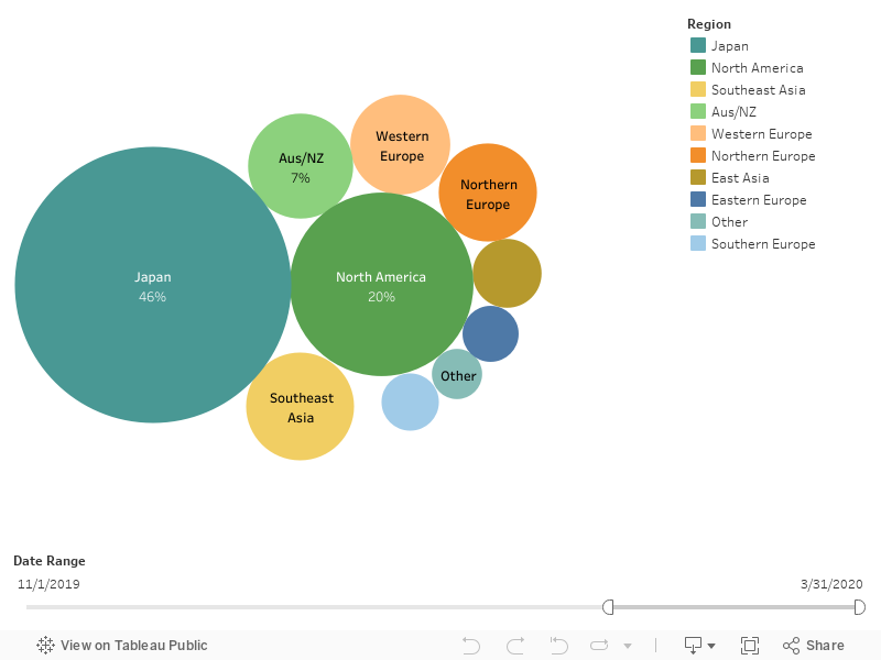
Sessions by region
Most popular posts/pages
Here’s a list of the most popular pages and/or posts on the site over the last five months (Nov 1st 2019 till Mar 31st 2020).
FINANCIAL HIGHLIGHTS
Hokkaido Wilds has two accounts – a ‘foundation’ account and an operational account.
- Foundation Account: The foundation account is a fund intended for donation to Hokkaido volunteer groups working towards a sustainable, safe, and accessible Hokkaido outdoors – see full details about the unofficial Hokkaido Wilds Foundation here. This fund is funded through direct revenue earned on the site via affiliate links etc. The vision here is to allow visitors to and residents of Hokkaido to indirectly contribute to sustaining the outdoor places they visit, through using our site. The main sorts of revenue-earning links we have are Amazon affiliate links (mainly links to Japanese ski touring and hiking guidebooks), GeoPDF map bundle sales, and an affiliate agreement with Explore-Share.com.
- No income? We’re not at all surprised that our current efforts at directly earning revenue on the site are not raking in great hoards of cash – we’re currently well below any affiliate link thresholds to get a payout. Tim Moss has written about this, and even top-shelf adventure websites such as bikepacking.com struggle despite having very clear advertising on the site. That said, as we continue to round out our content on the site, we’ll continue to work with Explore-Share.com and others to work on ways to unobtrusively utilize the site to give back to the outdoor community in Hokkaido.
- Operational Account: The operational account is funded through indirect revenue, such a speaker’s and consulting fees etc. We use these funds primarily for web and administrative costs at the moment.
Five-month period: 2019/11/1 – 2020/03/31 (yen)
| HOKKAIDOWILDS FUND INCOME | ||
|---|---|---|
| Affliate Link Income | 0 | |
| Total HokkaidoWilds Fund Income | 0 | |
| OPERATING FUNDING SOURCES | ||
|---|---|---|
| A) Carried over Nov 1, 2019 | 233,819 | |
| Map commission work | 30,000 | |
| B) Total income | 30,000 | |
| OPERATING EXPENSES | ||
| Panel printing (GeoActivity Contest) | 56,410 | |
| Tohoku Map Data Download | 5,340 | |
| C) Total expenses | 61,750 | |
| YEAR-END NET ASSETS as of 2019/3/31 (A+B)-C | 202,069 | |


